
Arithmetica
NCTech unveils new 360 degree imaging developments for iSTAR camera
NCTech announces new measurement capabilities and colorization integration for FARO laser scanners. NCTech, developer of reality imaging systems, announced two

NCTech announces new measurement capabilities and colorization integration for FARO laser scanners. NCTech, developer of reality imaging systems, announced two

Ordnance Survey is to supply mapping, geographic data and insights to UK Power Networks and Northumbrian Water in a contract

GeoSpatial Experts, specialised in photo-based mobile data collection, announced its reseller partnership agreement with WTH Technology, Inc., a provider of
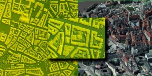
The new version 6.1 of the PHOTOMOD software family delivers the new dense DSM creation algorithm (SGM), the ability to

Two new Keynotes, Autodesk and NASA will be kicking off SPAR 3D Expo & Conference, which will be held April
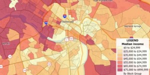
Caliper announced that the 2016 U.S. Census Blocks Groups data layer is now available for the entire United States. The

Trimble Unity 3.0 Adds New Features to it’s Smart Water Management Software to Ease Deployment and Connect Mobile Workers to

Blue Marble Geographics announced the immediate availability of version 7.2 of the GeoCalc SDK (Software Development Kit). This powerful toolkit