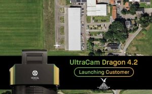
Slagboom & Peeters Aerial Surveys Becomes First Worldwide Customer of UltraCam Dragon 4.2
Vexcel Imaging announced that Dutch aerial survey company Slagboom & Peeters Aerial Surveys has purchased the very first UltraCam Dragon

Vexcel Imaging announced that Dutch aerial survey company Slagboom & Peeters Aerial Surveys has purchased the very first UltraCam Dragon

At INTERGEO Frankfurt 2025, RIEGL once again presents a broad range of innovations for the surveying industry. Powered by cutting-edge

Whether from space or from a drone’s perspective, whether with AI-powered data analytics or 3D visualizations: Geoinformation is no longer

Large-scale infrastructure projects, like highways and tunnels, are in a league of their own when it comes to volume of

The TatukGIS Developer Kernel is used in the development of the EJLSKOV Environmental Site Model Studio (ESM). Project managers and

Every major shift in how we understand our world has come from seeing it differently, from microscopes to telescopes, and

Leica Geosystems, part of Hexagon, introduced the Leica Pegasus TRK300, an adaptable system for various mobile mapping applications. Mobile mapping

Trimble announced Trimble Dimensions Australia, a new regional user conference taking place August 27-28 in Brisbane, Australia. Tailored for engineering

WGI, a leading national design and professional services firm headquartered in West Palm Beach, FL, finalized training at RIEGL USA

Topcon Positioning Systems has announced the expansion of its road construction portfolio, including improvements for road surface scanning, expanded aftermarket

A publication in Salon highlighted how LiDAR is transforming archaeology by uncovering ancient cities and historical sites. In his interview,

The Association for Geographic Information has moved its annual conference and flagship event GeoCom to Scotland. Taking place on Thursday

Hexagon has reached an agreement to acquire Septentrio, a leading OEM provider of GNSS technologies. This acquisition marks a significant

Laser-based data collection is becoming increasingly important in forest monitoring and the digitalization of forest inventories. RIEGL has earned an

Cadac Group announces the launch of its new, managed migration service for Autodesk Construction Cloud, a portfolio of software and

The Earth Observation (EO) Market is set for significant growth, according to the newly released 17th edition of the Earth

Public and private sector clients are pushing construction firms harder than ever before. As demand for larger, more complex projects

AI-InfraSolutions has been awarded the 2024 Technology Innovator award at the annual Bentley Partner Summit. The award has been presented

Nestled in the remote heights of the Ariège national park along the French-Spanish border, the Arcouzan glacier is one of

Emergency services will be given even greater support to carry out their critical tasks with the latest release of detailed

The INTERGEO EXPO and CONFERENCE 2024 successfully concluded in Stuttgart. The event, centered around geodesy, geoinformation, and land management, presented

RIEGL’s Ultimate LiDAR Technology offers a wide range of performance characteristics and serves as a platform for continuing Innovation in

Leica Geosystems, part of Hexagon, introduced the Leica GS05, a compact, lightweight GNSS Smart Antenna featuring calibration-free tilt compensation designed

In today’s fast-paced geospatial industry, the need for accurate, high-quality data is paramount. Enter the UltraCam Dragon 4.1—a revolutionary hybrid aerial
CMedia is publisher of GeoInformatics and BIGnieuws