
ClearSkies Geomatics Adds RIEGL VQ-1560 II-S
ClearSkies Geomatics Inc. (Colorado, USA) has invested in a RIEGL VQ-1560 II-S Airborne Laser Scanner as the foundation of their

ClearSkies Geomatics Inc. (Colorado, USA) has invested in a RIEGL VQ-1560 II-S Airborne Laser Scanner as the foundation of their

R-evolution, Hexagon’s sustainable innovation and green-tech investment subsidiary, announced the launch of its forest initiative Green Cubes to accelerate biodiversity

Geometricus d.o.o., a Croatian geodetic company started working with RIEGL UAV LiDAR Sensors in November 2022. Just a year later

NV5 Geospatial, North America’s most comprehensive geospatial data firm, announced ahead of the 103rd Transportation Research Board (TRB) Annual Meeting

Topcon Positioning Systems announces a series of new developments and initiatives as part of its ongoing sustainability efforts. First, the

Esri UK announced that AppyWay has joined its partner programme, giving Esri customers easy access to digital kerbside data for

National Highways has been announced as the only UK winner of an Esri Special Achievement in GIS Award, having won
Consulting and engineering firm Movares, specializing in solutions for rail, mobility, energy, and infrastructure challenges, has announced that it has

INTERGEO EXPO and CONFERENCE has come to a successful close after three days in Berlin. The leading international trade fair

From October 10 to 12, the exhibition halls of the capital Berlin will be transformed into a meeting place for

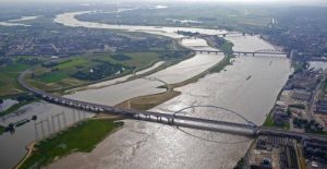
To maintain reliability and safety, many of the rail networks of Europe are undergoing a massive digital modernization that includes
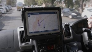
A new life-saving in-cab navigation application, underpinned by Ordnance Survey mapping, is being rolled out across all Ambulance Trusts in

An interview with Murphy Geospatial, which emphasises the importance of promoting the adoption of geospatial skills to shape the geospatial

Condor Aviation, a partnership between the Yurok Tribe’s Fisheries Department and Yurok Tribe Construction Corporation, acquired a RIEGL LiDAR sensor
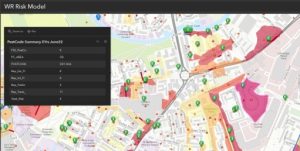
Anglian Water in the UK has created a real-time picture of sewer risk, which is helping drive proactive interventions to

In this 3D laser scanning case study you will discover how Terra Modus, a company specialising in 3D laser scanning
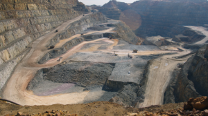
Minas de Ríotinto, located in the province of Huelva, in southwest Spain, is home to Europe’s largest mining pit, and

The seaside town of Køge lies just forty minutes south of Copenhagen in Denmark. A rapidly expanding area, new housing

EDF has used enterprise GIS from Esri UK to create a geospatial portal for Hinkley Point C (HPC) nuclear power

National providers of geospatial information are calling for sustained funding for pan-European mapping to ensure that the power of official

Scientists from VSL, TU Delft and VU Amsterdam have developed an alternative navigation system with an accuracy of 10 centimetres.
Phoenix LiDAR Systems has secured the world’s first purchase of the brand new RIEGL VUX-16023 Unmanned Laser Scanners to add to their

Vexcel Imaging announced the release of the new UltraCam Eagle 4.1, the pinnacle of nadir photogrammetric aerial camera systems increasing flight

Since its launch in 2009, Geovation, Ordnance Survey’s (OS) geospatial innovation hub, has welcomed and supported a plethora of innovative