
AppGeo
Sanborn acquires AppGeo and creates Geospatial Powerhouse
The Sanborn Map Company, Inc. (Sanborn) a geospatial solution provider of analytics, imagery, lidar, photogrammetry, software applications, and related services

The Sanborn Map Company, Inc. (Sanborn) a geospatial solution provider of analytics, imagery, lidar, photogrammetry, software applications, and related services

Takenaka Corporation, one of the largest general contractors in Japan, is strongly relying on the solutions from the Nemetschek Group

In 2021 Ordnance Survey (OS) helped support the creation of an automated, digital base map of Lusaka, Zambia, in partnership

GEO Business made a big impact on the UK geospatial profession as it returned to ExCeL London on 18-19 May.

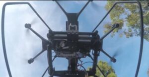
95West Aerial Mapping offers innovative data collection by integrating an UltraCam Eagle Mark 3 aerial camera system with a Riegl

Two Belgian adventurers are currently crossing Greenland on a triathlon including ski, kayak and a vertical rock climb. They have

Going house hunting? Ask yourself these 5 important questions during a viewing! The search for a new house is

We all expect customers to pay on time, but unfortunately, this is not always the reality. Using a debt collector

Our society faces major challenges such as climate change and loss of ecosystems. To address these challenges, we have to

For an unforgettable European road trip full of scenic routes, sights and experiences, be sure to consider the following routes.

Deswik is a global consulting and technology company that delivers efficiency focused solutions to the mining industry across all sectors

You were bitten by a dog and injured. Common injuries from a dog bite (Dutch: hondenbeet) consist of a bite

Business was booming once again at GEO Business, which returned last month on 24-25 November. The UK’s largest geospatial event

The new VQ-1560 II-S system, with its doubled laser power and high pulse frequency, will allow 95West Aerial Mapping to

Survey shows agile approach to authoritative cadastral and land registration is vital for Europe’s resilience and recovery programme. Interoperability,

Scholarship Program to Honor Technology Pioneer and Hidden Figure Who Helped Invent GPS. Trimble announced a scholarship program to

OS has become the latest organisation to join the charter, which was launched earlier this year as a set of

Agriculture is one of the world’s oldest and most important industries and it’s the key to feeding the future of
Drones – often referred to as unmanned aerial vehicles or UAVs – are becoming a valuable weapon in the arsenal

The University of Oxford has upgraded its estates management processes with a new indoor mapping system to provide more efficient

Colorado is often considered a rural state but when it comes to major cities, Denver is one of the fastest

A new mobile app, ArcGIS Field Maps, gives mobile workers a single app that can perform multiple critical field activities,

Ordnance Survey and Dubai Municipality sign for second year of a contract to create a Geospatial Services Centre in Dubai.

In February of 2019, the Bi-State Regional Commission (Iowa-Illinois) contracted Surdex Corporation for orthoimagery, lidar data and topographic mapping. The