AASHTO
How are Civil Infrastructure Professionals Using Drones in 2017?
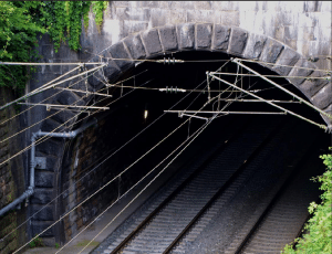
The inspection of structures like roads, highways, bridges, tunnels and railroads is a task that can often be made more efficient,

The inspection of structures like roads, highways, bridges, tunnels and railroads is a task that can often be made more efficient,
The significance of the new rules for non-hobbyist drone operations, aka Part 107 of the Federal Aviation Regulations, is monumental. Among countless other implications,

Aerial mapping company Bluesky has launched a new online Mapshop to serve the rapidly expanding mapping and geographic information industry

Stratasys Ltd., a 3D printing and additive manufacturing solutions company, has announced that it has partnered with the UK’s Manufacturing

Diversified Communications announced that SPAR 3D Expo & Conference will co-locate with AEC Science & Technology (AEC-ST), which recently joined

Trimble introduced version 3.10 of its Trimble® Pivot™ Platform software, a modular solution for real-time GNSS infrastructure management, ranging from