
Drone Mapping
Introducing MAP61: the next level of drone mapping efficiency
Consistently pushing the boundaries of what’s possible in drone mapping, Wingtra is excited to introduce MAP61, the most efficient mapping

Consistently pushing the boundaries of what’s possible in drone mapping, Wingtra is excited to introduce MAP61, the most efficient mapping

Leica Geosystems, part of Hexagon, introduced the Leica GS05, a compact, lightweight GNSS Smart Antenna featuring calibration-free tilt compensation designed
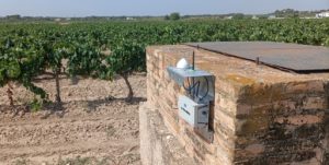
Trimble and Worldsensing announced the introduction of a solution for long term 3D ground and structural movement monitoring that will

PIX4Dcatch has been upgraded to offer improved compatibility with the Trimble DA2 positioning service, powered by Trimble Catalyst. This comprehensive

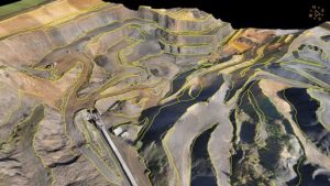
GeoLas Systems announced the launch of the ELMAP-P, a revolutionary airborne LiDAR pod designed specifically for Cessna aircraft models 172,
Virtual Surveyor has significantly reorganized its smart drone surveying software plans with the addition of the Productivity Tools suite to

This collaboration is set to create one of the world’s largest high-precision GNSS positioning service offers for the mass market,