
Ecopia AI has entered into a partnership with Maxar Intelligence to deliver high-precision mapping data on a truly global scale, with a commitment to generate more than one billion features worldwide.
Ecopia 3D Land Cover powered by Maxar is already supporting U.S. and international government agencies, as well as private-sector organizations, in applications such as basemapping, change detection, land-use planning, public safety, and other geospatial intelligence workflows. With more than a decade of experience producing large-scale geospatial data of high geometric accuracy, Ecopia now gains, through Maxar’s global satellite imagery, the ability to create and continuously maintain standardized, interoperable and high-precision mapping data virtually anywhere in the world.
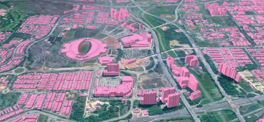
Eliminating the need for manual digitization
To generate this dataset, Ecopia’s AI-powered mapping engine extracts vector features with more than 95% geometric accuracy from Maxar’s decade-long archive of 30cm satellite imagery. As Maxar’s satellite constellation continues to capture fresh imagery on a daily basis, the data is consistently aligned across sensors and over time, ensuring positional stability and avoiding the “drift” that can undermine reliable basemap analysis.
This approach removes the need for traditional manual digitization and the ongoing upkeep of large-scale map data, tasks that are both resource-heavy and increasingly difficult to sustain as imagery grows. By automating feature extraction at continental scales, Ecopia delivers mapping datasets that can be refreshed as new imagery becomes available, while maintaining interoperability. The result is map data that is comprehensive, accurate, and consistently up to date, supporting a wide range of government and private-sector applications.
“Ecopia 3D Land Cover powered by Maxar solves one of the most persistent challenges in digital mapping – the time-consuming process of producing consistent vector map data of anywhere on Earth,” said Peter Wilczynski, Maxar’s chief product officer. “Together, we’ve created a product that eliminates the thousands of hours customers typically spend manually creating and aligning vectors. Instead, we’re bringing together the most accurate commercial satellite imagery and AI-powered technologies to deliver a dynamic 3D vector foundation that maintains fidelity as the world changes.”
“Gaining an up-to-date, three-dimensional understanding of our planet – and how it is changing – is one of the most complex challenges our customers face,” said Jon Lipinski, president and co-founder of Ecopia AI. “While millions of square kilometres of satellite images are captured each day, many organizations struggle to develop corresponding 3D vector maps and keep them current to reflect real-world change. This partnership with Maxar will enable unprecedented access to up-to-date 3D vector maps across the globe.”