
Every major shift in how we understand our world has come from seeing it differently, from microscopes to telescopes, and now, satellites.
Orbiting silently above us, these machines offer more than just pictures: they capture patterns, changes, and truths too complex to notice from the ground. But turning that flood of raw data into something usable? That takes more than technology. It takes vision.
EOS Data Analytics is at the forefront of that effort. Known for its precision and scale, the company combines AI with Earth observation to help clients across industries extract real value from satellite data, be it agriculture or climate research. Also, by offering an option of satellite image analysis by request, EOSDA enables organizations to access exactly the insights they need, tailored to their timing and goals.
About EOS Data Analytics
Building on its vision from the ground up, EOS Data Analytics has carved out a distinct role in the growing field of Earth observation. The company is trusted by a diverse network of partners. These include national governments addressing climate risks, agri-tech companies working to optimize yields, and researchers focused on modeling complex ecosystems. What truly distinguishes EOSDA is not just the breadth of its reach, but the accuracy of its insights.
At the heart of EOSDA’s work is the integration of satellite data with artificial intelligence. Rather than relying on isolated snapshots from space, the company creates dynamic datasets that evolve over time and reflect real-world conditions. Its proprietary algorithms process imagery from multiple satellite sources, converting raw data into detailed, actionable insights. These cover a wide range of indicators such as crop health, soil moisture, vegetation patterns, and deforestation risk.
EOSDA’s real strength lies in its ability to scale. Its tools are effective whether they are being used on a 20-hectare family farm or as part of a national forestry program covering millions of hectares. Because sustainability is a central focus of the company’s mission, its analytics are designed to meet business needs while also promoting environmental stewardship. In today’s world, where land-use decisions have global implications, this balanced approach is more important than ever. By turning complex Earth observation into accessible solutions, EOSDA is redefining what’s possible in geospatial data analytics — not just watching the planet change, but helping shape how we respond.
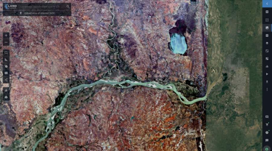
While EOS Data Analytics powers global decision-making at scale, its platform EOSDA LandViewer brings that power directly into users’ hands, whether they’re environmental analysts, real estate developers, or farmers tracking crop health. Designed to make satellite data both accessible and actionable, EOSDA LandViewer offers a streamlined experience for anyone seeking clarity from above. At its core, the platform is a powerful gateway to a vast and diverse catalog of satellite imagery, featuring data from more than 45 satellites and constellations. Users can search for any area on the planet and instantly access both recent and historical images, with resolution options ranging from standard to sub-meter. This flexibility allows for everything from casual exploration to highly detailed, industry-grade analysis.
The platform’s tools are built not just for browsing but for extracting real meaning from remote sensing data. With over 20 indices and preset band combinations, users can monitor vegetation health, detect land changes, assess water presence, and more. All without needing advanced technical knowledge. Features like time-series analysis and side-by-side image comparison make it easy to visualize change over time, while dynamic time-lapse creation helps users communicate insights in engaging, visual formats.
What sets EOSDA LandViewer apart is its evolving focus. As of 2025, new updates are being rolled out to support underrepresented sectors such as construction and urban planning. This includes new environmental datasets, digital terrain models, and user-friendly onboarding experiences tailored to different industries. Whether you’re working on a large-scale infrastructure project or simply curious about your surroundings, EOSDA LandViewer is designed to meet you where you are and grow with you from there.
EOSDA Crop Monitoring
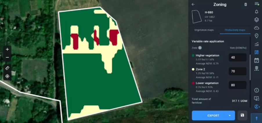
This satellite-based precision agriculture platform is designed to take the guesswork out of field management, offering farmers and agronomists real-time access to crop conditions, weather insights, and activity planning, all in one unified interface. What makes EOSDA Crop Monitoring stand out is its depth of integration. The platform pulls together a rich blend of satellite data, historical trends, field-level weather forecasts, vegetation indices, and user-generated scouting reports. This fusion empowers users to detect problems like disease, water stress, pests, and nutrient deficiencies early, before they become yield losses. And thanks to variable-rate application (VRA) maps, resources like fertilizer, seeds, and pesticides can be applied precisely where they’re needed, reducing costs and environmental impact.
2024 marked a significant leap forward for the platform. With updates like cloud shadow masking, PlanetScope data integration, and enhanced vegetation indices (including NDYI, NRFI, and NDPI), EOSDA has taken remote sensing and agronomic analytics to new heights. These additions allow for even more accurate interpretation of crop health, especially during sensitive stages like flowering and early growth. For teams managing large operations, the platform’s Team Account functionality centralizes field data access and task coordination. From assigning scouts to specific problem zones, to tracking activities offline in the mobile app, the entire workflow becomes streamlined and efficient. And with the new Latest Image Layer, field boundaries can be drawn with precision using the freshest, clearest imagery available.
EOSDA Carbon
EOS Data Analytics has long been known for turning satellite geospatial data into smarter land decisions. With EOSDA Carbon, the company brings that same precision and innovation to one of the most pressing climate challenges: measuring and maximizing soil organic carbon (SOC) for carbon credit generation. At the heart of EOSDA Carbon is a science-backed modeling system that blends machine learning, high-resolution satellite data, and a deep library of 140 environmental and soil predictors. This combination significantly reduces the need for costly, time-consuming field sampling without sacrificing accuracy. Built on an enhanced version of the RothC model, EOSDA’s approach allows carbon project developers and governments to predict, monitor, and report SOC changes across diverse regions with confidence and scale.
Whether you’re building a carbon offset project, developing national climate policy, or optimizing your farm for long-term sustainability, EOSDA Carbon transforms geospatial data analysis into measurable environmental and financial returns.
Petro Kogut has a PhD in Physics and Mathematics and is the author of multiple scientific publications. Among other topics, he has a specific focus on a satellite imagery processing and application in his academic research. Currently, Prof. Dr. Petro Kogut also works a science advisor.