
Osprey
Vexcel Imaging announces the newest UltraCam Osprey 4.2
Vexcel Imaging introduces the UltraCam Osprey 4.2, the latest evolution in large-format nadir and oblique aerial imaging technology. Building upon

Vexcel Imaging introduces the UltraCam Osprey 4.2, the latest evolution in large-format nadir and oblique aerial imaging technology. Building upon

European Space Imaging (EUSI) and Albedo, a builder of high-performance spacecraft and the first satellite designed to operate commercially in
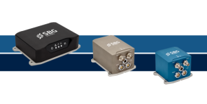
SBG Systems announced an expansion of its high-performance inertial navigation systems, Ekinox, Apogee, and Navsight, with new GNSS receiver options.

Xona Space Systems, a leading pioneer of advanced commercial satellite navigation solutions announces a new collaboration with Trimble. Xona and
Virtual Surveyor has added Basic Topographic Design tools to Version 10 of its smart drone surveying package allowing users to
NV5 announced that lidar-derived data of the Palisades Fire and the Eaton Fire burn areas are now freely available to

The agreement is expected to expand access to cutting-edge digital reality solutions and result in complementary product developments, such as

The Association for Geographic Information has launched a new project exploring the opportunities and challenges for the sector over the
As one of the leading providers of UAV-based laser scanning solutions, RIEGL will be present at the first XPONENTIAL Europe

Wingtra has introduced MAP61, an efficient mapping sensor enabling professionals to generate larger mapping outputs in less time. With the

Topcon Positioning Systems and Pix4D have announced a strategic agreement that combines their expertise in geopositioning and photogrammetry solutions. The

Fugro has acquired EOMAP GmbH & Co. KG (EOMAP), market leader in mapping and monitoring of marine and freshwater environments
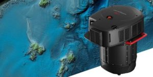
Leica Geosystems, part of Hexagon, announced the launch of the Leica CoastalMapper. Thanks to a wider field of view and

Pix4D, a global leader in photogrammetry and geospatial software solutions, announced a partnership with Freefly Systems, a renowned innovator in

Leica Geosystems, part of Hexagon, announces a new partnership with the Southern California Institute of Architecture (SCI-Arc), created to help

Topcon Positioning Systems has announced a significant expansion of its Topnet Live reference station network, introducing 200 new geodetic stations

Preston City Council (PCC) has the Cadcorp Geographic Information System (GIS) deployed throughout the council and is accessible to the

Cyclomedia recently showcased its innovative integrated platform for pavement and asset data collection. This all-in-one solution is set to transform

Croydon Council has selected location intelligence company Cadcorp to supply cloud hosted Geographical Information System (GIS) and web mapping. The

Septentrio announces the extension of its mosaicTM family of compact GNSS receiver modules with the mosaic-G5 receiver range. These new

CHC Navigation has introduced the X500 rotor UAV, designed to meet the demands of precision aerial operations. Its capabilities make

TomTom, the location technology specialist, announced a partnership with Esri to integrate its global map and traffic data into ArcGIS’s

Trimble and GroundProbe, part of Orica Digital Solutions specializing in real-time solutions for measuring and monitoring geohazards, have announced a

Frontier Agriculture has signed a new partnership with Esri UK, enabling it to create advanced geospatial solutions for the UK