
3D
Joint development projects Siemens with Bentley Systems
In his keynote at Bentley’s annual event, Helmuth Ludwig, Global Head of Information Technology for Siemens, presented a scenario illustrating

In his keynote at Bentley’s annual event, Helmuth Ludwig, Global Head of Information Technology for Siemens, presented a scenario illustrating
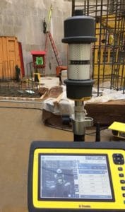
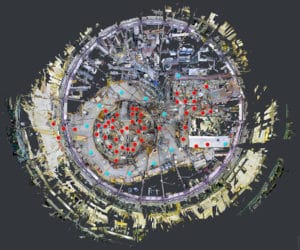
It’s hard enough to build a complex, 12-story industrial structure. Try putting one into a deep, concrete-lined hole. Twice. That’s

Ever wondered what the name of that hill is in the distance? Or how far away a town is from
Leica Geosystems and Matterport, a cloud-based 3D media company, announced a partnership to deliver a fast, simple solution for creating,

After three incredibly successful days in Berlin, INTERGEO 2017 has drawn to a close. The trade fair and conference have

New processing tools save time and improve quality on scanning and imaging projects. In 2000, a 3D laser scanner could

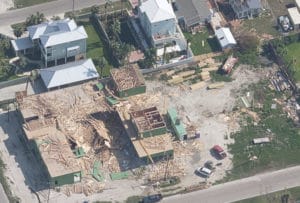
A tanker carrying 2,500 tonnes of oil and fuel sank near Athens on September 10, polluting the Greek coastline. European
In partnership with the National Insurance Crime Bureau (NICB), Vexcel Imaging has been leading a coalition of geospatial firms to

The production of Airbus’ four new very high resolution satellites, which together will form the Pléiades Neo constellation, is well

As a city evolves, how do you ensure you make the right decisions and meet the needs of the people?

A remarkable silhouette is appearing on the skyline of Antwerp, the capital of the eponymous province in Belgium. Ever since

Every city has a unique story to tell, but lately, the stories of the biggest cities have begun to sound

National Survey Solutions (NSS), formerly known as Northern Surveying Services, have been in the surveying and construction industry for over

Plowman Craven, a UK survey and measurement company, has launched the Vogel R3D system that deploys unmanned aerial vehicles (drones)

Bentley Systems announced the finalists in the 2017 Be Inspired Awards program. The annual awards honor the extraordinary work of

HP announced a unified approach and commercial solutions for virtual reality (VR), positioning itself as the partner of choice for

When geo IT experts from the worlds of business and science sat down together at a roundtable for INTERGEO and

Col-East International Ltd., a provider of aerial photogrammetric services in the Northeast U.S., has been contracted to perform an airborne

Hong Kong recently published a digital guide with all sorts of useful maps and mapbooks freely available for download by

From 26 to 28 September 2017, the international UAV sector will be demonstrating its potential at INTERAERIAL SOLUTIONS in Berlin.

Carbomap, an environmental survey company, in collaboration with high performance LiDAR manufacturer RIEGL, UAVE and The University of Edinburgh, announced

Watch the video below and let the Esri software development teams who build ArcGIS Pro take you on a grand

It’s the coldest, driest and windiest continent on Earth which many might understandably prefer to leave well enough alone. It

From 20-22 June, the SQUARE Brussels Exhibition Centre in Brussels, Belgium, was the scene of Commercial UAV Expo Europe, the