
3D
Drone inspections go nuclear with GPS and RADAR
How do you inspect a structure that’s almost 160 m high and 120 m in diameter? With a few weeks

How do you inspect a structure that’s almost 160 m high and 120 m in diameter? With a few weeks

Digitalisation and the ubiquitous availability of images have resulted in a new golden age for photogrammetry! The driving force behind

Leica Geosystems released Leica Spider v7.0 software suite, supporting Galileo and QZSS constellations as well as the GPS-L5 signal for

The ongoing debate about smart/digital cities, which has simmered for some time, now is really heating up. A wealth of
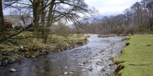
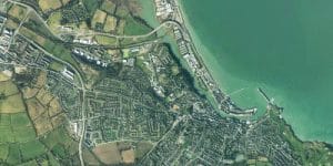
Aerial photography from Bluesky is being used to identify changes in sediment movement in upland river courses, to help assess
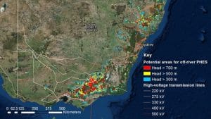
With most coal and gas power stations slated for retirement over the next 15 years, Australia’s hills and mountains provide

In 1987, a group of photogrammetric professionals envisioned a product that would bridge the gap between a stereoplotter and the

The 2017 INTERGEO season is underway, with a programme fully reflecting its long-standing key focus – “Knowledge and action for

Cities are the vibrant hubs at the heart of our society. They are the source of many pioneering developments. They
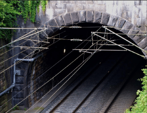
The inspection of structures like roads, highways, bridges, tunnels and railroads is a task that can often be made more efficient,
The significance of the new rules for non-hobbyist drone operations, aka Part 107 of the Federal Aviation Regulations, is monumental. Among countless other implications,

The International Society for Photogrammetry and Remote Sensing is proud to announce a new ISPRS award. Individual awards are presented
Civil Maps, a developer of cognition systems for autonomous vehicles, announced the release of the Atlas DevKit platform, a hardware
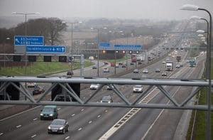
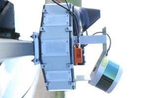
Not so long ago the thought of remotely monitoring the condition and performance of the UK’s 7,000km network of trunk
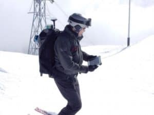
What is wearable mapping technology? Cameras, laser sensors, and software worn on the back like a comfortable hiking backpack, keeping

BMW Group and Mobileye announced that they have signed an agreement introducing Mobileye’s Road Experience Management (REM™) data generation technology

The Munich-based company European Space Imaging (EUSI) has been awarded another major supply contract for VHR satellite data and services
Scientists at The University of Nottingham are using radar waves as part of a new tool developed to evaluate peatland

Dating from 1917, RAF Duxford in Cambridgeshire grew during two world wars into an important fighter air station, famed for

It would seem there is little understanding of professions within the built environment and few young people aspire to a

Logic Instrument, manufacturer of rugged mobile computers, extends its range of professional Fieldbook tablets with a new model that combines

Hexagon Safety & Infrastructure and RapidSOS have partnered to provide public safety agencies that use Hexagon’s Intergraph® Computer-Aided Dispatch (I/CAD) with accurate location and additional data from the RapidSOS NG911 Clearinghouse.

Trimble announced that NS Groep N.V. (NS), the Dutch state-owned rail company, will be deploying the Trimble R2M real-time remote
EastWest Mapping has purchased detailed aerial photography and height data from Bluesky Geospatial to update and enhance its recreational maps.