
Aggregates & Mining
Commercial UAV Expo Hits it out of the Park
With a second successful edition under its belt and widespread enthusiasm for the event on the part of exhibitors, attendees

With a second successful edition under its belt and widespread enthusiasm for the event on the part of exhibitors, attendees
European Space Imaging (EUSI) completed the 2015 Controls with Remote Sensing (CwRS) program for the European Commission (EC) with 100

Trimble introduced the Trimble Catalyst, a software-defined Global Navigation Satellite System (GNSS) receiver that works with select Android mobile handhelds,

Bentley Systems, Incorporated, reported respects in which China sets the pace globally for BIM advancements. This year, the independent juries

Tuffwing, a manufacturer of aerial mapping systems recently performed integration of Emlid Reach RTK to enable making precision maps without

For land surveyors, and other mapping and measurement professionals, photo capture of 3D environments can seem like yet another sudden

This year’s European Satellite Navigation Competition, the world’s leading innovation platform for forward-thinking applications in its field, centred on the
Ecometrica, a software and data company, is set to help take the guesswork out of predicting future floods, crop yields,

The world is getting smart. At the heart of these tumultuous changes to our lives, economy and work lies digitalisation.

Teledyne Optech announced it has partnered with The Ocean Cleanup in their Aerial Expedition research mission, where the Optech CZMIL

In the Netherlands there are many waterways, small inland harbors and canals that are used by citizens in their daily

Independent brewers, Thornbridge, are improving delivery costs, increasing driver efficiency and minimising the environmental impact of their mobile operation following

NuGeneration Limited (NuGen) plans to build a nuclear power station of up to 3.8GW* gross capacity at Moorside, close to

Bentley Systems announced the project finalists in the 2016 Be Inspired Awards program. The annual awards honor the extraordinary work

InterDrone, The International Drone Conference & Exposition held at the Paris Hotel in Las Vegas Sept 7-9, drew 3,518 attendees

Worldwide, policy makers and stakeholders alike are tasked with shaping change of societies. Whether setting goals for growth, identifying timelines,

MARSAT consortium announced it is ready to provide innovative space-based applications using satellite-derived information for the maritime and coastal industry.

To coincide with the new Small UAS Rule, aka Part 107, Commercial UAV News announced the release of a free
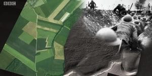
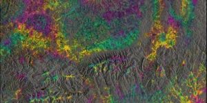
An aerial survey using aircraft mounted lasers has revealed previously undiscovered evidence that might potentially help to dispute accusations of

It’s almost as if augmented reality (AR) had only just been invented. Pokémon Go – the revival of the classic

Brazil will be teeming with tourists this summer, with an extra half-a-million visitors expected in Rio de Janeiro during August
Lehmann Aviation announced the launch of a totally new L-A Series line of professional mapping drones for operators around the

The new sector for hardware and software manufacturers and service providers in the UAS industry is incredibly dynamic. As part

Two out of five surveyors have been affected by lost or stolen equipment, with the average cost of replacing the